
By Naomi Weiss and Michael Vandi
Maps are an integral part of our everyday lives. We use them to navigate our way around, check the weather, or look up information for places we want to visit. However, about 70 percent of the world is not mapped in an open and accessible data source with any meaningful level of detail. Additionally, our environment is constantly changing and maps need to adapt to this change and remain relevant. Platforms like OpenStreetMap help to make this process easier, open, and accessible.
OpenStreetMap is a free and collaborative map that allows the general public to add and edit map features. The project was started in 2004 and relies primarily on crowdsourced data made available under the open database license. As of August 2020, there were a total of 6.7 million registered users on OpenStreetMap, 6.25 billion nodes, and 4.5 million map changes are made every day. OpenStreetMap is also used by numerous companies, platforms, and organizations such as Amazon, Facebook, and the United Nations.
The advent of COVID-19 is an example of how the world around us can change in a short time. New resources like COVID-19 testing sites, treatment centers, and food delivery locations need to be presented to the general public via an open system that everyone can access. In the Data Science Corps, one of our tasks was to add the locations of all COVID-19 testing sites in and around Baltimore city to OpenStreetMap.
Adding a COVID-19 testing site on OpenStreetMap simply requires a computer, a modern web browser, and a stable internet connection. The OpenStreetMap editor makes it very easy for people with no prior GIS experience to add new points on the map. The steps can be condensed into first finding the location where you want to add a point, choosing between three primary options: Point, Line, and Area, adding all necessary information about the location, and finally submitting the edit. See an example of a COVID-19 testing site we added to OpenStreetMap.
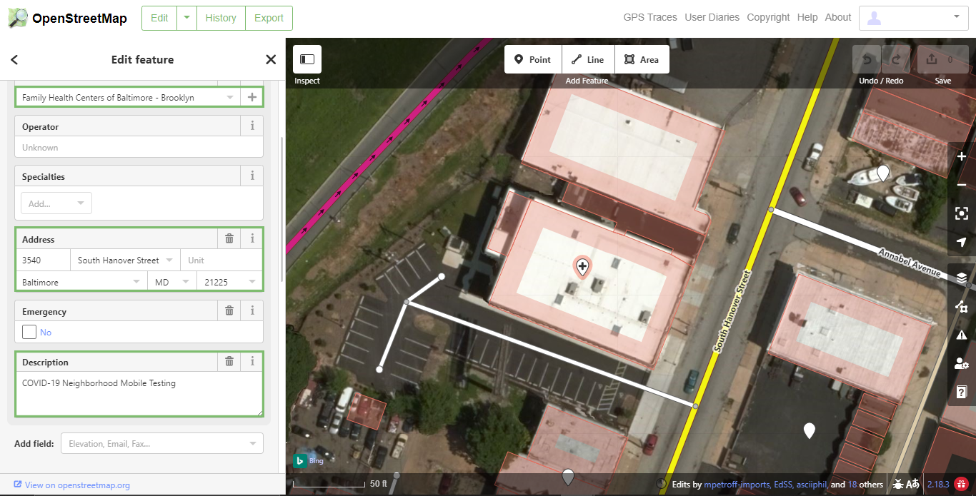 Family Health Centers of Baltimore – COVID-19 Testing Site
The testing site shown above was added with the OpenStreetMap iD (in-browser) editor. To the left is the Edit Feature Panel which shows tags from the location selected on the map. From here you can add or edit tags for this location. In this case, we added a name, an address, and a description tag.
OpenStreetMap is a very large community. Many users contributing new points and editing old ones means that there is a greater quantity of points added and helps ensure that data is accurate and current. We encountered some testing sites that had already been added. For example, the University of Maryland Medical Testing in downtown Baltimore was already on the map but some important data was missing, such as the type of testing available and contact information. Because OpenStreetMap is a community-oriented platform, it is also possible to edit or even delete points that were added by other people. This feature helps to keep information on the platform up to date.
Our work with OpenStreetMap did not stop with COVID-19 testing sites. During Baltimore Data Week, BNIA collaborated with a cartographic group in Baltimore, MaptimeBmore, to organize a virtual Mapathon. Mapathon participants helped map green spaces in Baltimore. The theme of the Mapathon was to address neighborhood data gaps and improve the agricultural map coverage of the Baltimore area including trees, forests, and natural wood. A total of over 2000 points were added to OpenStreetMap in as little as two hours. Attendees described the event as fun and therapeutic.
In the future, data science students can add new points on OpenStreetMap, as well as edit existing points if information changes. Students could also use information from OpenStreetMaps to build useful tools, such as a tool to look up nearby COVID-19 testing sites and get appointment times and directions.
Overall, our work with OpenStreetMap was not only exciting but also meaningful. Many individuals and organizations around the world use OpenStreetMap on a daily basis and the impact created by the platform can be seen in many real-world applications. Every time you order an Uber, book a trip on TripAdvisor or share a photo on Flickr, you are using OpenStreetMap.